


Stevenson 4

Chabard
User

Length
27 km

Max alt
1238 m

Uphill gradient
576 m
Km-Effort
35 km

Min alt
899 m

Downhill gradient
614 m
Boucle
No
Creation date :
2025-06-29 06:39:45.0
Updated on :
2025-06-29 15:00:06.379
8h18
Difficulty : Difficult

FREE GPS app for hiking
 SityTrail
IGN / Geographical institutes
SityTrail Plus
The world is yours!
About
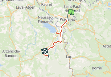
Trail Walking of 27 km to be discovered at Auvergne-Rhône-Alpes, Haute-Loire, Pradelles. This trail is proposed by Chabard.
Description
Pradelles - Cheylard-l’Évêque
Positioning
Country:
France
Region :
Auvergne-Rhône-Alpes
Department/Province :
Haute-Loire
Municipality :
Pradelles
Location:
Unknown
Start:(Dec)
Start:(UTM)
569826 ; 4957903 (31T) N.
Comments