


Chaumont sur Loire

jeannine grandjean
User
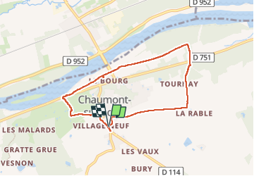

Length
7.1 km

Max alt
113 m

Uphill gradient
77 m
Km-Effort
8.1 km

Min alt
58 m

Downhill gradient
78 m
Boucle
Yes
Creation date :
2025-07-01 05:26:56.0
Updated on :
2025-07-01 08:40:58.004

FREE GPS app for hiking
 SityTrail
IGN / Geographical institutes
SityTrail Plus
The world is yours!
About
Trail of 7.1 km to be discovered at Centre-Loire Valley, Loir-et-Cher, Chaumont-sur-Loire. This trail is proposed by jeannine grandjean.
Positioning
Country:
France
Region :
Centre-Loire Valley
Department/Province :
Loir-et-Cher
Municipality :
Chaumont-sur-Loire
Location:
Unknown
Start:(Dec)
Start:(UTM)
363728 ; 5259500 (31T) N.
Comments