


3e in

bernir
User
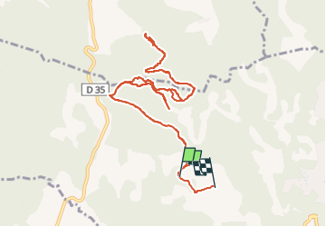

Length
14.9 km

Max alt
395 m

Uphill gradient
272 m
Km-Effort
18.6 km

Min alt
306 m

Downhill gradient
287 m
Boucle
No
Creation date :
2025-06-30 07:03:29.286
Updated on :
2025-07-01 14:31:31.597
4h58
Difficulty : Difficult

FREE GPS app for hiking
 SityTrail
IGN / Geographical institutes
SityTrail Plus
The world is yours!
About
Trail Walking of 14.9 km to be discovered at Provence-Alpes-Côte d'Azur, Var, Barjols. This trail is proposed by bernir.
Positioning
Country:
France
Region :
Provence-Alpes-Côte d'Azur
Department/Province :
Var
Municipality :
Barjols
Location:
Unknown
Start:(Dec)
Start:(UTM)
740097 ; 4827154 (31T) N.
Comments