


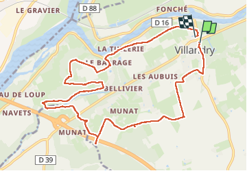
villandry

RoMo
User

Length
11.7 km

Max alt
90 m

Uphill gradient
103 m
Km-Effort
13.1 km

Min alt
38 m

Downhill gradient
109 m
Boucle
Yes
Creation date :
2025-06-30 07:33:07.516
Updated on :
2025-07-01 19:37:47.064
2h36
Difficulty : Medium

FREE GPS app for hiking
 SityTrail
IGN / Geographical institutes
SityTrail Plus
The world is yours!
About
Trail Walking of 11.7 km to be discovered at Centre-Loire Valley, Indre-et-Loire, Villandry. This trail is proposed by RoMo.
Description
boucle par gr 3 et sentier découverte
Photos


Positioning
Country:
France
Region :
Centre-Loire Valley
Department/Province :
Indre-et-Loire
Municipality :
Villandry
Location:
Unknown
Start:(Dec)
Start:(UTM)
312024 ; 5245978 (31T) N.
Comments