


circuit du lac des cordes.2025.06.27

trusgnachjf
User
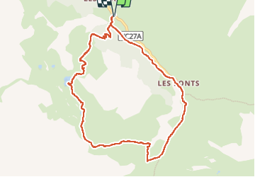

Length
10.2 km

Max alt
2599 m

Uphill gradient
657 m
Km-Effort
19 km

Min alt
1959 m

Downhill gradient
658 m
Boucle
Yes
Creation date :
2025-06-27 07:34:06.794
Updated on :
2025-07-02 13:34:03.782
5h59
Difficulty : Difficult

FREE GPS app for hiking
 SityTrail
IGN / Geographical institutes
SityTrail Plus
The world is yours!
About
Trail Walking of 10.2 km to be discovered at Provence-Alpes-Côte d'Azur, Hautes-Alpes, Cervières. This trail is proposed by trusgnachjf.
Positioning
Country:
France
Region :
Provence-Alpes-Côte d'Azur
Department/Province :
Hautes-Alpes
Municipality :
Cervières
Location:
Unknown
Start:(Dec)
Start:(UTM)
326218 ; 4969348 (32T) N.
Comments