


2025-06-05_2299180818_Boucle Sumène-Artense — Romain Bardet Expérience - RBX

laudub
User
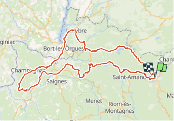

Length
102 km

Max alt
986 m

Uphill gradient
1939 m
Km-Effort
128 km

Min alt
403 m

Downhill gradient
1938 m
Boucle
Yes
Creation date :
2025-07-02 14:49:18.0
Updated on :
2025-07-02 14:49:19.48

FREE GPS app for hiking
 SityTrail
IGN / Geographical institutes
SityTrail Plus
The world is yours!
About
Trail of 102 km to be discovered at Auvergne-Rhône-Alpes, Cantal, Condat. This trail is proposed by laudub.
Positioning
Country:
France
Region :
Auvergne-Rhône-Alpes
Department/Province :
Cantal
Municipality :
Condat
Location:
Unknown
Start:(Dec)
Start:(UTM)
481196 ; 5020897 (31T) N.
Comments