


thin le moutier

lousim22
User
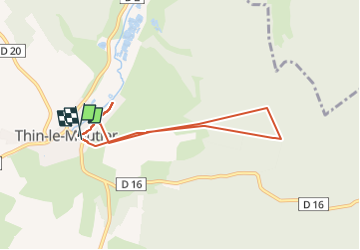

Length
6.2 km

Max alt
286 m

Uphill gradient
133 m
Km-Effort
8 km

Min alt
180 m

Downhill gradient
129 m
Boucle
Yes
Creation date :
2025-07-03 07:44:20.911
Updated on :
2025-07-03 09:58:52.015
2h14
Difficulty : Medium

FREE GPS app for hiking
 SityTrail
IGN / Geographical institutes
SityTrail Plus
The world is yours!
About
Trail Walking of 6.2 km to be discovered at Grand Est, Ardennes, Thin-le-Moutier. This trail is proposed by lousim22.
Positioning
Country:
France
Region :
Grand Est
Department/Province :
Ardennes
Municipality :
Thin-le-Moutier
Location:
Unknown
Start:(Dec)
Start:(UTM)
608430 ; 5508458 (31U) N.
Comments