


ARCA PIERRE PERCÉE

Gatge
User

Length
12.4 km

Max alt
498 m

Uphill gradient
312 m
Km-Effort
16.5 km

Min alt
383 m

Downhill gradient
309 m
Boucle
Yes
Creation date :
2025-07-03 07:44:28.823
Updated on :
2025-07-03 12:49:38.729
3h21
Difficulty : Easy

FREE GPS app for hiking
 SityTrail
IGN / Geographical institutes
SityTrail Plus
The world is yours!
About
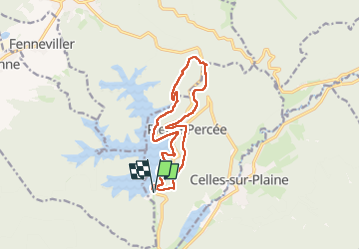
Trail Walking of 12.4 km to be discovered at Grand Est, Meurthe-et-Moselle, Pierre-Percée. This trail is proposed by Gatge.
Photos


Positioning
Country:
France
Region :
Grand Est
Department/Province :
Meurthe-et-Moselle
Municipality :
Pierre-Percée
Location:
Unknown
Start:(Dec)
Start:(UTM)
346305 ; 5368850 (32U) N.
Comments