


Aubin 1

papajp
User
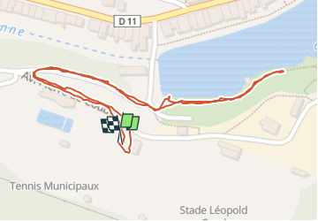

Length
814 m

Max alt
279 m

Uphill gradient
9 m
Km-Effort
933 m

Min alt
264 m

Downhill gradient
9 m
Boucle
Yes
Creation date :
2025-07-03 12:34:07.0
Updated on :
2025-07-03 13:03:58.423
29m
Difficulty : Unknown

FREE GPS app for hiking
 SityTrail
IGN / Geographical institutes
SityTrail Plus
The world is yours!
About
Trail Walking of 814 m to be discovered at Occitania, Aveyron, Aubin. This trail is proposed by papajp.
Photos

Positioning
Country:
France
Region :
Occitania
Department/Province :
Aveyron
Municipality :
Aubin
Location:
Unknown
Start:(Dec)
Start:(UTM)
441271 ; 4930610 (31T) N.
Comments