


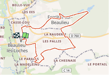
Beaulieu les Loches

RoMo
User

Length
11.4 km

Max alt
129 m

Uphill gradient
137 m
Km-Effort
13.2 km

Min alt
73 m

Downhill gradient
137 m
Boucle
Yes
Creation date :
2025-07-04 06:59:58.48
Updated on :
2025-07-04 12:02:09.505
2h36
Difficulty : Easy

FREE GPS app for hiking
 SityTrail
IGN / Geographical institutes
SityTrail Plus
The world is yours!
About
Trail Walking of 11.4 km to be discovered at Centre-Loire Valley, Indre-et-Loire, Beaulieu-lès-Loches. This trail is proposed by RoMo.
Description
belle boucle
Photos


Positioning
Country:
France
Region :
Centre-Loire Valley
Department/Province :
Indre-et-Loire
Municipality :
Beaulieu-lès-Loches
Location:
Unknown
Start:(Dec)
Start:(UTM)
349419 ; 5221520 (31T) N.
Comments