


04/07/2025 - De Carolles à St Jean Le Thomas.Virtuel

babeth35
User
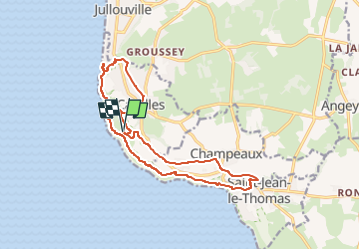

Length
15.4 km

Max alt
88 m

Uphill gradient
335 m
Km-Effort
19.9 km

Min alt
9 m

Downhill gradient
336 m
Boucle
Yes
Creation date :
2025-07-04 15:05:50.259
Updated on :
2025-07-04 15:06:57.268
4h31
Difficulty : Easy
4h31
Difficulty : Very difficult

FREE GPS app for hiking
 SityTrail
IGN / Geographical institutes
SityTrail Plus
The world is yours!
About
Trail On foot of 15.4 km to be discovered at Normandy, Manche, Carolles. This trail is proposed by babeth35.
Positioning
Country:
France
Region :
Normandy
Department/Province :
Manche
Municipality :
Carolles
Location:
Unknown
Start:(Dec)
Start:(UTM)
605471 ; 5399927 (30U) N.
Comments