


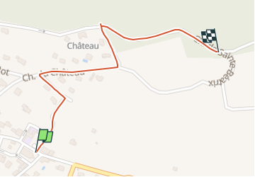
RD-Ornacieux-Crx de Beatrix

raymondfn
User

Length
841 m

Max alt
521 m

Uphill gradient
82 m
Km-Effort
1.7 km

Min alt
434 m

Downhill gradient
0 m
Boucle
No
Creation date :
2025-07-05 11:31:39.885
Updated on :
2025-07-05 11:32:22.636
22m
Difficulty : Easy

FREE GPS app for hiking
 SityTrail
IGN / Geographical institutes
SityTrail Plus
The world is yours!
About
Trail Walking of 841 m to be discovered at Auvergne-Rhône-Alpes, Isère, Ornacieux-Balbins. This trail is proposed by raymondfn.
Positioning
Country:
France
Region :
Auvergne-Rhône-Alpes
Department/Province :
Isère
Municipality :
Ornacieux-Balbins
Location:
Ornacieux
Start:(Dec)
Start:(UTM)
673295 ; 5029640 (31T) N.
Comments