


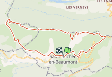
La Crête de la Sciau

rapako
User

Length
11.8 km

Max alt
1488 m

Uphill gradient
495 m
Km-Effort
18.4 km

Min alt
1193 m

Downhill gradient
498 m
Boucle
Yes
Creation date :
2025-07-05 14:21:57.831
Updated on :
2025-07-05 14:23:21.608
4h11
Difficulty : Difficult

FREE GPS app for hiking
 SityTrail
IGN / Geographical institutes
SityTrail Plus
The world is yours!
About
Trail Walking of 11.8 km to be discovered at Auvergne-Rhône-Alpes, Isère, Saint-Michel-en-Beaumont. This trail is proposed by rapako.
Description
En passant par le Col de Parquetout et le Grand Clos
Positioning
Country:
France
Region :
Auvergne-Rhône-Alpes
Department/Province :
Isère
Municipality :
Saint-Michel-en-Beaumont
Location:
Unknown
Start:(Dec)
Start:(UTM)
729072 ; 4972396 (31T) N.
Comments