


Les hauts de Domfaing

francoisecarlier
User
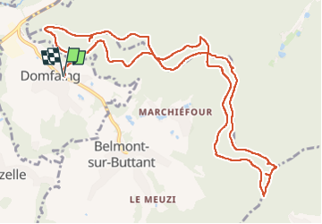

Length
13.3 km

Max alt
639 m

Uphill gradient
435 m
Km-Effort
19.1 km

Min alt
378 m

Downhill gradient
435 m
Boucle
Yes
Creation date :
2025-07-06 10:03:39.0
Updated on :
2025-07-24 17:18:32.63
4h20
Difficulty : Easy

FREE GPS app for hiking
 SityTrail
IGN / Geographical institutes
SityTrail Plus
The world is yours!
About
Trail Walking of 13.3 km to be discovered at Grand Est, Vosges, Domfaing. This trail is proposed by francoisecarlier.
Photos


Positioning
Country:
France
Region :
Grand Est
Department/Province :
Vosges
Municipality :
Domfaing
Location:
Unknown
Start:(Dec)
Start:(UTM)
333131 ; 5344865 (32U) N.
Comments