


Cascade de la Vernière

Clo0413
User
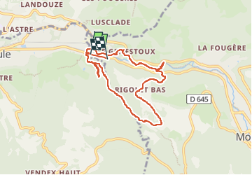

Length
8.1 km

Max alt
1105 m

Uphill gradient
304 m
Km-Effort
12 km

Min alt
890 m

Downhill gradient
258 m
Boucle
No
Creation date :
2025-07-06 12:07:18.782
Updated on :
2025-07-15 15:29:42.362
2h08
Difficulty : Easy

FREE GPS app for hiking
 SityTrail
IGN / Geographical institutes
SityTrail Plus
The world is yours!
About
Trail Walking of 8.1 km to be discovered at Auvergne-Rhône-Alpes, Puy-de-Dôme, Mont-Dore. This trail is proposed by Clo0413.
Positioning
Country:
France
Region :
Auvergne-Rhône-Alpes
Department/Province :
Puy-de-Dôme
Municipality :
Mont-Dore
Location:
Unknown
Start:(Dec)
Start:(UTM)
481864 ; 5048441 (31T) N.
Comments