


col de Proncel

jcschubnel
User
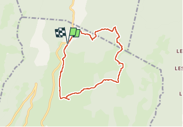

Length
7.7 km

Max alt
1113 m

Uphill gradient
159 m
Km-Effort
9.9 km

Min alt
1046 m

Downhill gradient
160 m
Boucle
Yes
Creation date :
2025-07-05 06:55:46.249
Updated on :
2025-07-07 15:29:58.15
3h01
Difficulty : Medium

FREE GPS app for hiking
 SityTrail
IGN / Geographical institutes
SityTrail Plus
The world is yours!
About
Trail Walking of 7.7 km to be discovered at Auvergne-Rhône-Alpes, Drôme, Vassieux-en-Vercors. This trail is proposed by jcschubnel.
Positioning
Country:
France
Region :
Auvergne-Rhône-Alpes
Department/Province :
Drôme
Municipality :
Vassieux-en-Vercors
Location:
Unknown
Start:(Dec)
Start:(UTM)
687996 ; 4977667 (31T) N.
Comments