


Puy St Vincent station 2000 vers Narreyrous

caze
User
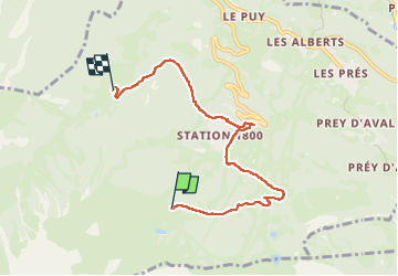

Length
6.2 km

Max alt
2073 m

Uphill gradient
124 m
Km-Effort
8.9 km

Min alt
1665 m

Downhill gradient
428 m
Boucle
No
Creation date :
2025-07-06 12:11:27.0
Updated on :
2025-07-07 15:30:13.964
3h18
Difficulty : Medium

FREE GPS app for hiking
 SityTrail
IGN / Geographical institutes
SityTrail Plus
The world is yours!
About
Trail Walking of 6.2 km to be discovered at Provence-Alpes-Côte d'Azur, Hautes-Alpes, Puy-Saint-Vincent. This trail is proposed by caze.
Positioning
Country:
France
Region :
Provence-Alpes-Côte d'Azur
Department/Province :
Hautes-Alpes
Municipality :
Puy-Saint-Vincent
Location:
Unknown
Start:(Dec)
Start:(UTM)
300275 ; 4964926 (32T) N.
Comments