


Chalet - Colmars - L'Espinier - Chalet

soca
User
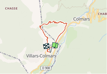

Length
5.9 km

Max alt
1583 m

Uphill gradient
376 m
Km-Effort
10.9 km

Min alt
1216 m

Downhill gradient
376 m
Boucle
Yes
Creation date :
2025-07-07 19:11:02.206
Updated on :
2025-07-07 19:11:02.206
2h28
Difficulty : Medium

FREE GPS app for hiking
 SityTrail
IGN / Geographical institutes
SityTrail Plus
The world is yours!
About
Trail Walking of 5.9 km to be discovered at Provence-Alpes-Côte d'Azur, Alpes-de-Haute-Provence, Villars-Colmars. This trail is proposed by soca.
Positioning
Country:
France
Region :
Provence-Alpes-Côte d'Azur
Department/Province :
Alpes-de-Haute-Provence
Municipality :
Villars-Colmars
Location:
Unknown
Start:(Dec)
Start:(UTM)
308876 ; 4893266 (32T) N.
Comments