


Le Menez Hom - 30-07-2015

jmrobin
User
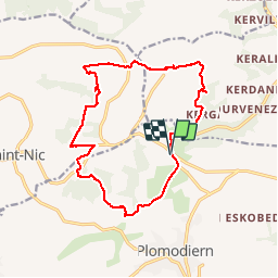

Length
15.4 km

Max alt
326 m

Uphill gradient
412 m
Km-Effort
21 km

Min alt
66 m

Downhill gradient
413 m
Boucle
Yes
Creation date :
2019-03-04 10:38:03.515
Updated on :
2019-03-04 10:38:03.542
3h42
Difficulty : Medium

FREE GPS app for hiking
 SityTrail
IGN / Geographical institutes
SityTrail Plus
The world is yours!
About
Trail Walking of 15.4 km to be discovered at Brittany, Finistère, Plomodiern. This trail is proposed by jmrobin.
Positioning
Country:
France
Region :
Brittany
Department/Province :
Finistère
Municipality :
Plomodiern
Location:
Unknown
Start:(Dec)
Start:(UTM)
408295 ; 5339474 (30U) N.
Comments