


Le lac St bonnet

verozerr
User
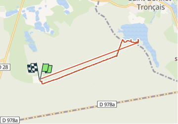

Length
6.4 km

Max alt
273 m

Uphill gradient
96 m
Km-Effort
7.7 km

Min alt
224 m

Downhill gradient
94 m
Boucle
Yes
Creation date :
2025-07-08 08:17:34.89
Updated on :
2025-07-08 10:23:41.662
2h05
Difficulty : Medium

FREE GPS app for hiking
 SityTrail
IGN / Geographical institutes
SityTrail Plus
The world is yours!
About
Trail Walking of 6.4 km to be discovered at Auvergne-Rhône-Alpes, Allier, Braize. This trail is proposed by verozerr.
Description
entre Le lac et le camping
Positioning
Country:
France
Region :
Auvergne-Rhône-Alpes
Department/Province :
Allier
Municipality :
Braize
Location:
Unknown
Start:(Dec)
Start:(UTM)
473566 ; 5165439 (31T) N.
Comments