


Elanceze depuis Trielle juillet 2025

Chabard
User

Length
17.4 km

Max alt
1552 m

Uphill gradient
743 m
Km-Effort
27 km

Min alt
1019 m

Downhill gradient
759 m
Boucle
Yes
Creation date :
2025-07-08 07:35:21.0
Updated on :
2025-07-08 12:45:43.706
5h09
Difficulty : Medium

FREE GPS app for hiking
 SityTrail
IGN / Geographical institutes
SityTrail Plus
The world is yours!
About
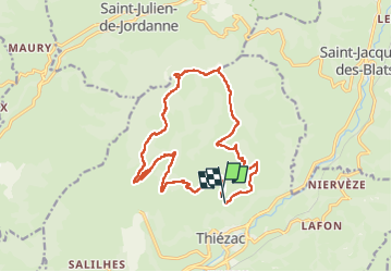
Trail Walking of 17.4 km to be discovered at Auvergne-Rhône-Alpes, Cantal, Thiézac. This trail is proposed by Chabard.
Description
Elanceze depuis Trielle juillet 2025
Positioning
Country:
France
Region :
Auvergne-Rhône-Alpes
Department/Province :
Cantal
Municipality :
Thiézac
Location:
Unknown
Start:(Dec)
Start:(UTM)
473636 ; 4985554 (31T) N.
Comments