ANSE CARITAN-ANSE MEUNIER A-R

magic97232
User
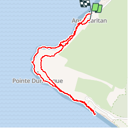

Length
3.3 km

Max alt
30 m

Uphill gradient
45 m
Km-Effort
3.9 km

Min alt
4 m

Downhill gradient
47 m
Boucle
Yes
Creation date :
2016-03-09 00:00:00.0
Updated on :
2016-03-09 00:00:00.0
1h23
Difficulty : Very easy

FREE GPS app for hiking
 SityTrail
IGN / Geographical institutes
SityTrail Plus
The world is yours!
About
Trail Walking of 3.3 km to be discovered at Martinique, Unknown, Sainte-Anne. This trail is proposed by magic97232.
Positioning
Country:
France
Region :
Martinique
Department/Province :
Unknown
Municipality :
Sainte-Anne
Location:
Unknown
Start:(Dec)
Start:(UTM)
727652 ; 1595648 (20P) N.
Comments