


X1

ffffff
User
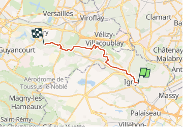

Length
14.5 km

Max alt
178 m

Uphill gradient
250 m
Km-Effort
17.6 km

Min alt
64 m

Downhill gradient
202 m
Boucle
No
Creation date :
2025-07-09 12:40:58.67
Updated on :
2025-07-09 12:41:02.636
4h00
Difficulty : Difficult

FREE GPS app for hiking
 SityTrail
IGN / Geographical institutes
SityTrail Plus
The world is yours!
About
Trail Walking of 14.5 km to be discovered at Ile-de-France, Essonne, Igny. This trail is proposed by ffffff.
Positioning
Country:
France
Region :
Ile-de-France
Department/Province :
Essonne
Municipality :
Igny
Location:
Unknown
Start:(Dec)
Start:(UTM)
443804 ; 5398865 (31U) N.
Comments