


approche

rochedaniel
User

Length
819 m

Max alt
1885 m

Uphill gradient
31 m
Km-Effort
1.2 km

Min alt
1843 m

Downhill gradient
26 m
Boucle
No
Creation date :
2015-07-31 00:00:00.0
Updated on :
2015-07-31 00:00:00.0
10m
Difficulty : Very easy

FREE GPS app for hiking
 SityTrail
IGN / Geographical institutes
SityTrail Plus
The world is yours!
About
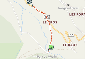
Trail Walking of 819 m to be discovered at Provence-Alpes-Côte d'Azur, Hautes-Alpes, Saint-Véran. This trail is proposed by rochedaniel.
Positioning
Country:
France
Region :
Provence-Alpes-Côte d'Azur
Department/Province :
Hautes-Alpes
Municipality :
Saint-Véran
Location:
Unknown
Start:(Dec)
Start:(UTM)
330351 ; 4951583 (32T) N.
Comments