


piste

chrispaquet
User
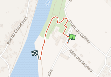

Length
560 m

Max alt
372 m

Uphill gradient
4 m
Km-Effort
616 m

Min alt
363 m

Downhill gradient
5 m
Boucle
Yes
Creation date :
2025-07-10 08:30:00.601
Updated on :
2025-07-10 08:40:55.992
10m
Difficulty : Easy

FREE GPS app for hiking
 SityTrail
IGN / Geographical institutes
SityTrail Plus
The world is yours!
About
Trail Walking of 560 m to be discovered at Auvergne-Rhône-Alpes, Loire, Saint-Just-Saint-Rambert. This trail is proposed by chrispaquet.
Positioning
Country:
France
Region :
Auvergne-Rhône-Alpes
Department/Province :
Loire
Municipality :
Saint-Just-Saint-Rambert
Location:
Saint-Just-sur-Loire
Start:(Dec)
Start:(UTM)
598480 ; 5039141 (31T) N.
Comments