


château de la Roche

vazitonton
User
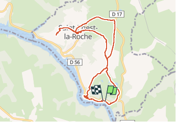

Length
10.5 km

Max alt
450 m

Uphill gradient
232 m
Km-Effort
13.6 km

Min alt
318 m

Downhill gradient
233 m
Boucle
Yes
Creation date :
2025-07-10 07:36:02.866
Updated on :
2025-07-10 11:46:01.783
2h52
Difficulty : Difficult

FREE GPS app for hiking
 SityTrail
IGN / Geographical institutes
SityTrail Plus
The world is yours!
About
Trail Walking of 10.5 km to be discovered at Auvergne-Rhône-Alpes, Loire, Saint-Priest-la-Roche. This trail is proposed by vazitonton.
Positioning
Country:
France
Region :
Auvergne-Rhône-Alpes
Department/Province :
Loire
Municipality :
Saint-Priest-la-Roche
Location:
Unknown
Start:(Dec)
Start:(UTM)
585563 ; 5083153 (31T) N.
Comments