


Signal Relais Majestic

cohard
User
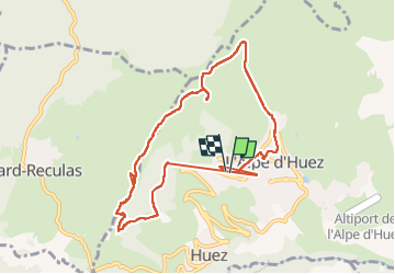

Length
9.6 km

Max alt
2111 m

Uphill gradient
473 m
Km-Effort
16 km

Min alt
1721 m

Downhill gradient
483 m
Boucle
Yes
Creation date :
2025-07-10 09:04:40.742
Updated on :
2025-07-10 12:45:25.987
2h24
Difficulty : Difficult

FREE GPS app for hiking
 SityTrail
IGN / Geographical institutes
SityTrail Plus
The world is yours!
About
Trail Walking of 9.6 km to be discovered at Auvergne-Rhône-Alpes, Isère, Huez. This trail is proposed by cohard.
Positioning
Country:
France
Region :
Auvergne-Rhône-Alpes
Department/Province :
Isère
Municipality :
Huez
Location:
Unknown
Start:(Dec)
Start:(UTM)
268885 ; 4997277 (32T) N.
Comments