Trail Walking Laveissière - Cinq sommets depuis Le Lioran - juillet 2025 - Photo

Cinq sommets depuis Le Lioran - juillet 2025

 Chabard
Chabard

User

© OpenStreetMap contributors
Length
Length
16.2 km
Max alt
Max alt
1786 m
Uphill gradient
Uphill gradient
1007 m
Km-Effort
Km-Effort  
30 km
Min alt
Min alt
1225 m
Downhill gradient
Downhill gradient
1007 m
Boucle
Boucle
Yes
Creation date :
2025-07-10 06:54:36.0
Updated on :
2025-07-10 16:07:28.751

(0 Reviews)

Walking
Walking
6h02
Difficulty : Difficult

Scan this QR Code to open this trail in the SityTrail application

FREE GPS app for hiking

Logo SityTrail SityTrail

IGN / Geographical institutes

Download SityTrail from the App Store Download SityTrail from Google Play

Logo SityTrail SityTrail Plus

The world is yours!

Download SityTrail from the App Store Download SityTrail from Google Play Download SityTrail on Huawei AppGallery

About

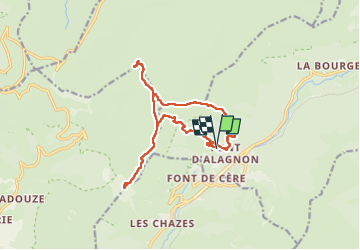
Trail Walking of 16.2 km to be discovered at Auvergne-Rhône-Alpes, Cantal, Laveissière. This trail is proposed by Chabard.

Description

Départ Font d’Alagnon
Montée au Bec de l'Aigle (il faut mettre les mains à certains passages)
Montée au téton de Vénus
Montée au Puy de Bataillouse
Descente sur le Col de Cabre
Montée au Puy de Peyre-Arse
Redescente et passage au Col de Cabre et au Col de Rombière
Montée au Puy Griou
Redescente sur le Col de Rombière puis sur la Font d'ALagnon

Elevation profile

Positioning

Country:
France
Region :
Auvergne-Rhône-Alpes
Department/Province :
Cantal
Municipality :
Laveissière
Location:
Unknown
Start:(Dec)
Start:(UTM)
479375 ; 4992988 (31T) N.


Close
My subscriptions