


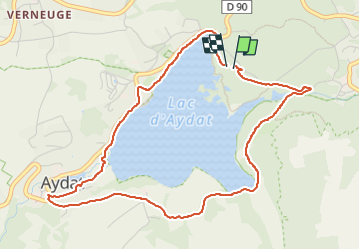
Camping du lac d'Aydat - Tour du lac.

cordierlavenant
User

Length
5.3 km

Max alt
880 m

Uphill gradient
85 m
Km-Effort
6.4 km

Min alt
837 m

Downhill gradient
83 m
Boucle
Yes
Creation date :
2025-07-11 07:45:58.777
Updated on :
2025-07-11 08:56:08.437
1h09
Difficulty : Easy

FREE GPS app for hiking
 SityTrail
IGN / Geographical institutes
SityTrail Plus
The world is yours!
About
Trail Walking of 5.3 km to be discovered at Auvergne-Rhône-Alpes, Puy-de-Dôme, Aydat. This trail is proposed by cordierlavenant.
Positioning
Country:
France
Region :
Auvergne-Rhône-Alpes
Department/Province :
Puy-de-Dôme
Municipality :
Aydat
Location:
Unknown
Start:(Dec)
Start:(UTM)
499251 ; 5057137 (31T) N.
Comments