


Gare de l’Ayré

hugha
User
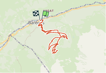

Length
12.3 km

Max alt
2006 m

Uphill gradient
758 m
Km-Effort
22 km

Min alt
1226 m

Downhill gradient
767 m
Boucle
Yes
Creation date :
2025-07-11 08:28:59.0
Updated on :
2025-07-11 12:52:10.936

FREE GPS app for hiking
 SityTrail
IGN / Geographical institutes
SityTrail Plus
The world is yours!
About
Trail of 12.3 km to be discovered at Occitania, Hautespyrenees, Barèges. This trail is proposed by hugha.
Description
Aller retour Barèges
Positioning
Country:
France
Region :
Occitania
Department/Province :
Hautespyrenees
Municipality :
Barèges
Location:
Unknown
Start:(Dec)
Start:(UTM)
260401 ; 4753550 (31T) N.
Comments