


2025 06 15 vimet

bernardcollignon
User
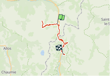

Length
12.3 km

Max alt
2888 m

Uphill gradient
823 m
Km-Effort
23 km

Min alt
2059 m

Downhill gradient
824 m
Boucle
Yes
Creation date :
2025-06-15 07:33:02.927
Updated on :
2025-08-15 16:09:43.084
5h17
Difficulty : Very difficult

FREE GPS app for hiking
 SityTrail
IGN / Geographical institutes
SityTrail Plus
The world is yours!
About
Trail Walking of 12.3 km to be discovered at Provence-Alpes-Côte d'Azur, Alpes-de-Haute-Provence, Uvernet-Fours. This trail is proposed by bernardcollignon.
Positioning
Country:
France
Region :
Provence-Alpes-Côte d'Azur
Department/Province :
Alpes-de-Haute-Provence
Municipality :
Uvernet-Fours
Location:
Unknown
Start:(Dec)
Start:(UTM)
319786 ; 4905482 (32T) N.
Comments