


essai

PatriceCocuaud
User
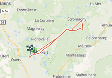

Length
23 km

Max alt
477 m

Uphill gradient
492 m
Km-Effort
29 km

Min alt
296 m

Downhill gradient
475 m
Boucle
No
Creation date :
2025-07-12 09:24:10.482
Updated on :
2025-07-12 11:34:18.724
2h05
Difficulty : Medium

FREE GPS app for hiking
 SityTrail
IGN / Geographical institutes
SityTrail Plus
The world is yours!
About
Trail Mountain bike of 23 km to be discovered at Bourgogne-Franche-Comté, Haute-Saône, Franchevelle. This trail is proposed by PatriceCocuaud.
Positioning
Country:
France
Region :
Bourgogne-Franche-Comté
Department/Province :
Haute-Saône
Municipality :
Franchevelle
Location:
Unknown
Start:(Dec)
Start:(UTM)
309533 ; 5290292 (32T) N.
Comments