


Sources de gillardes monestier.boucle

clintest
User
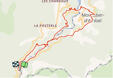

Length
13.4 km

Max alt
976 m

Uphill gradient
483 m
Km-Effort
19.9 km

Min alt
772 m

Downhill gradient
490 m
Boucle
Yes
Creation date :
2025-07-12 06:44:21.737
Updated on :
2025-07-12 17:16:47.125
4h48
Difficulty : Very difficult

FREE GPS app for hiking
 SityTrail
IGN / Geographical institutes
SityTrail Plus
The world is yours!
About
Trail Walking of 13.4 km to be discovered at Auvergne-Rhône-Alpes, Isère, Pellafol. This trail is proposed by clintest.
Positioning
Country:
France
Region :
Auvergne-Rhône-Alpes
Department/Province :
Isère
Municipality :
Pellafol
Location:
Unknown
Start:(Dec)
Start:(UTM)
728505 ; 4960040 (31T) N.
Comments