


Vincennes

lm178
User
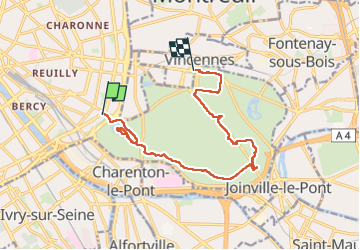

Length
12.1 km

Max alt
73 m

Uphill gradient
89 m
Km-Effort
13.3 km

Min alt
43 m

Downhill gradient
86 m
Boucle
No
Creation date :
2025-07-12 06:31:45.805
Updated on :
2025-07-12 18:00:09.028
3h13
Difficulty : Very easy

FREE GPS app for hiking
 SityTrail
IGN / Geographical institutes
SityTrail Plus
The world is yours!
About
Trail Walking of 12.1 km to be discovered at Ile-de-France, Paris, Paris. This trail is proposed by lm178.
Positioning
Country:
France
Region :
Ile-de-France
Department/Province :
Paris
Municipality :
Paris
Location:
12th Arrondissement
Start:(Dec)
Start:(UTM)
456451 ; 5409275 (31U) N.
Comments