


frouzins lacs inversé juillet 25

pidjam
User
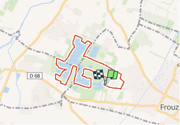

Length
9.1 km

Max alt
179 m

Uphill gradient
54 m
Km-Effort
9.8 km

Min alt
167 m

Downhill gradient
53 m
Boucle
Yes
Creation date :
2025-07-13 07:03:05.969
Updated on :
2025-07-13 09:26:18.636
2h10
Difficulty : Easy

FREE GPS app for hiking
 SityTrail
IGN / Geographical institutes
SityTrail Plus
The world is yours!
About
Trail Walking of 9.1 km to be discovered at Occitania, Haute-Garonne, Frouzins. This trail is proposed by pidjam.
Positioning
Country:
France
Region :
Occitania
Department/Province :
Haute-Garonne
Municipality :
Frouzins
Location:
Unknown
Start:(Dec)
Start:(UTM)
362561 ; 4820126 (31T) N.
Comments