


col du Lisey

sdroneau
User
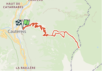

Length
15.6 km

Max alt
2101 m

Uphill gradient
1172 m
Km-Effort
31 km

Min alt
960 m

Downhill gradient
1170 m
Boucle
Yes
Creation date :
2025-07-13 05:02:20.145
Updated on :
2025-07-13 09:28:12.648
4h09
Difficulty : Very difficult

FREE GPS app for hiking
 SityTrail
IGN / Geographical institutes
SityTrail Plus
The world is yours!
About
Trail Walking of 15.6 km to be discovered at Occitania, Hautespyrenees, Cauterets. This trail is proposed by sdroneau.
Positioning
Country:
France
Region :
Occitania
Department/Province :
Hautespyrenees
Municipality :
Cauterets
Location:
Unknown
Start:(Dec)
Start:(UTM)
735888 ; 4752693 (30T) N.
Comments