


Chalet des Bannettes

Emelle
User
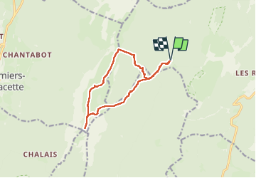

Length
12.1 km

Max alt
1757 m

Uphill gradient
555 m
Km-Effort
19.5 km

Min alt
1294 m

Downhill gradient
556 m
Boucle
Yes
Creation date :
2025-07-10 06:56:29.11
Updated on :
2025-07-13 12:26:12.892
6h49
Difficulty : Medium

FREE GPS app for hiking
 SityTrail
IGN / Geographical institutes
SityTrail Plus
The world is yours!
About
Trail Walking of 12.1 km to be discovered at Auvergne-Rhône-Alpes, Isère, Saint-Pierre-de-Chartreuse. This trail is proposed by Emelle.
Positioning
Country:
France
Region :
Auvergne-Rhône-Alpes
Department/Province :
Isère
Municipality :
Saint-Pierre-de-Chartreuse
Location:
Unknown
Start:(Dec)
Start:(UTM)
714652 ; 5022665 (31T) N.
Comments