


Les crêtes du Capucin au Sancy

Clo0413
User
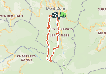

Length
13.5 km

Max alt
1727 m

Uphill gradient
782 m
Km-Effort
24 km

Min alt
1051 m

Downhill gradient
778 m
Boucle
Yes
Creation date :
2025-07-11 07:35:13.878
Updated on :
2025-07-15 13:50:09.981
3h56
Difficulty : Medium

FREE GPS app for hiking
 SityTrail
IGN / Geographical institutes
SityTrail Plus
The world is yours!
About
Trail Walking of 13.5 km to be discovered at Auvergne-Rhône-Alpes, Puy-de-Dôme, Mont-Dore. This trail is proposed by Clo0413.
Positioning
Country:
France
Region :
Auvergne-Rhône-Alpes
Department/Province :
Puy-de-Dôme
Municipality :
Mont-Dore
Location:
Unknown
Start:(Dec)
Start:(UTM)
485427 ; 5045664 (31T) N.
Comments