


Lacs de Liantran

chasle
User
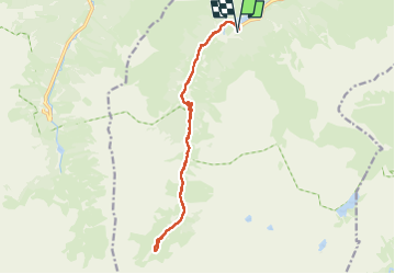

Length
16.9 km

Max alt
1827 m

Uphill gradient
749 m
Km-Effort
27 km

Min alt
1161 m

Downhill gradient
749 m
Boucle
Yes
Creation date :
2025-07-13 06:11:39.869
Updated on :
2025-07-13 16:55:24.478
5h18
Difficulty : Difficult

FREE GPS app for hiking
 SityTrail
IGN / Geographical institutes
SityTrail Plus
The world is yours!
About
Trail Walking of 16.9 km to be discovered at Occitania, Hautespyrenees, Estaing. This trail is proposed by chasle.
Positioning
Country:
France
Region :
Occitania
Department/Province :
Hautespyrenees
Municipality :
Estaing
Location:
Unknown
Start:(Dec)
Start:(UTM)
727637 ; 4753853 (30T) N.
Comments