


Col de la Haugade par le Lac d'Ilheou

lebarça
User
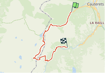

Length
14.8 km

Max alt
2380 m

Uphill gradient
1067 m
Km-Effort
28 km

Min alt
1347 m

Downhill gradient
892 m
Boucle
No
Creation date :
2025-07-13 07:12:42.0
Updated on :
2025-08-04 11:35:04.378
7h14
Difficulty : Difficult

FREE GPS app for hiking
 SityTrail
IGN / Geographical institutes
SityTrail Plus
The world is yours!
About
Trail Walking of 14.8 km to be discovered at Occitania, Hautespyrenees, Cauterets. This trail is proposed by lebarça.
Positioning
Country:
France
Region :
Occitania
Department/Province :
Hautespyrenees
Municipality :
Cauterets
Location:
Unknown
Start:(Dec)
Start:(UTM)
733351 ; 4751739 (30T) N.
Comments