


J1 Trachère-Vignec-Agos

ETMU5496
User
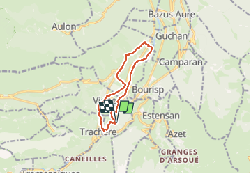

Length
11.3 km

Max alt
1051 m

Uphill gradient
407 m
Km-Effort
16.7 km

Min alt
768 m

Downhill gradient
408 m
Boucle
Yes
Creation date :
2025-07-14 08:46:35.0
Updated on :
2025-07-19 17:14:17.392
3h47
Difficulty : Medium

FREE GPS app for hiking
 SityTrail
IGN / Geographical institutes
SityTrail Plus
The world is yours!
About
Trail Walking of 11.3 km to be discovered at Occitania, Hautespyrenees, Saint-Lary-Soulan. This trail is proposed by ETMU5496.
Description
IBP=50
Photos


Positioning
Country:
France
Region :
Occitania
Department/Province :
Hautespyrenees
Municipality :
Saint-Lary-Soulan
Location:
Unknown
Start:(Dec)
Start:(UTM)
281105 ; 4743867 (31T) N.
Comments