


R2-DD-Nanteuil Charly sur Marne

RANDOH
User
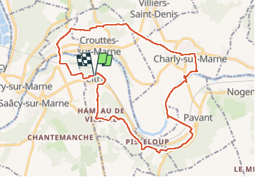

Length
20 km

Max alt
187 m

Uphill gradient
345 m
Km-Effort
25 km

Min alt
53 m

Downhill gradient
343 m
Boucle
Yes
Creation date :
2025-07-14 07:52:02.224
Updated on :
2025-07-14 14:32:26.895
6h39
Difficulty : Difficult

FREE GPS app for hiking
 SityTrail
IGN / Geographical institutes
SityTrail Plus
The world is yours!
About
Trail Walking of 20 km to be discovered at Ile-de-France, Seine-et-Marne, Citry. This trail is proposed by RANDOH.
Positioning
Country:
France
Region :
Ile-de-France
Department/Province :
Seine-et-Marne
Municipality :
Citry
Location:
Unknown
Start:(Dec)
Start:(UTM)
517434 ; 5424156 (31U) N.
Comments