


GTA jour 6

yvesconnes
User
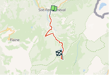

Length
15.3 km

Max alt
2253 m

Uphill gradient
1551 m
Km-Effort
32 km

Min alt
831 m

Downhill gradient
390 m
Boucle
No
Creation date :
2025-07-14 06:47:15.671
Updated on :
2025-07-14 17:57:43.406
6h40
Difficulty : Difficult

FREE GPS app for hiking
 SityTrail
IGN / Geographical institutes
SityTrail Plus
The world is yours!
About
Trail Walking of 15.3 km to be discovered at Auvergne-Rhône-Alpes, Upper Savoy, Sixt-Fer-à-Cheval. This trail is proposed by yvesconnes.
Positioning
Country:
France
Region :
Auvergne-Rhône-Alpes
Department/Province :
Upper Savoy
Municipality :
Sixt-Fer-à-Cheval
Location:
Unknown
Start:(Dec)
Start:(UTM)
327495 ; 5101592 (32T) N.
Comments