


lac de longemer le hohneck

grattounette
User
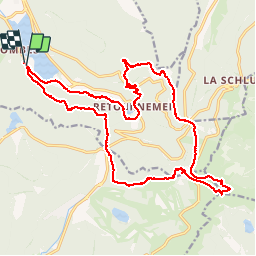

Length
22 km

Max alt
1355 m

Uphill gradient
982 m
Km-Effort
35 km

Min alt
735 m

Downhill gradient
983 m
Boucle
Yes
Creation date :
2015-08-01 00:00:00.0
Updated on :
2015-08-01 00:00:00.0
7h38
Difficulty : Medium

FREE GPS app for hiking
 SityTrail
IGN / Geographical institutes
SityTrail Plus
The world is yours!
About
Trail Walking of 22 km to be discovered at Grand Est, Vosges, Xonrupt-Longemer. This trail is proposed by grattounette.
Description
lac de longemer, roche du diable, ferme de balveurche, le collet, le hohneck, le haut chitelet col des faignes
Positioning
Country:
France
Region :
Grand Est
Department/Province :
Vosges
Municipality :
Xonrupt-Longemer
Location:
Unknown
Start:(Dec)
Start:(UTM)
347173 ; 5325805 (32U) N.
Comments
Magnifique; décors variésFait en mode trail mars 2017, très intéressant