


Gta jour 7

yvesconnes
User
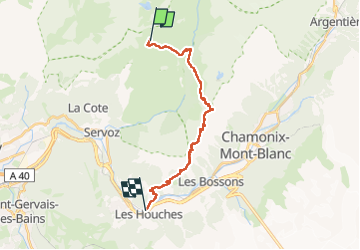

Length
20 km

Max alt
2508 m

Uphill gradient
1036 m
Km-Effort
38 km

Min alt
975 m

Downhill gradient
2049 m
Boucle
No
Creation date :
2025-07-15 05:59:50.969
Updated on :
2025-07-15 16:49:03.602
7h55
Difficulty : Very difficult

FREE GPS app for hiking
 SityTrail
IGN / Geographical institutes
SityTrail Plus
The world is yours!
About
Trail Walking of 20 km to be discovered at Auvergne-Rhône-Alpes, Upper Savoy, Passy. This trail is proposed by yvesconnes.
Positioning
Country:
France
Region :
Auvergne-Rhône-Alpes
Department/Province :
Upper Savoy
Municipality :
Passy
Location:
Unknown
Start:(Dec)
Start:(UTM)
329616 ; 5093612 (32T) N.
Comments