


osbroek

karlaenjo
User
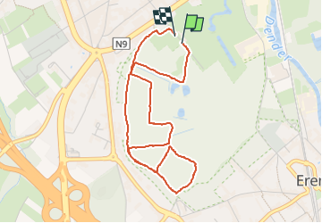

Length
4.2 km

Max alt
25 m

Uphill gradient
39 m
Km-Effort
4.7 km

Min alt
8 m

Downhill gradient
38 m
Boucle
Yes
Creation date :
2025-07-16 08:57:47.567
Updated on :
2025-07-16 09:45:39.389
47m
Difficulty : Easy

FREE GPS app for hiking
 SityTrail
IGN / Geographical institutes
SityTrail Plus
The world is yours!
About
Trail Walking of 4.2 km to be discovered at Flanders, East Flanders, Aalst. This trail is proposed by karlaenjo.
Description
osbroek aalst
Positioning
Country:
Belgium
Region :
Flanders
Department/Province :
East Flanders
Municipality :
Aalst
Location:
Aalst
Start:(Dec)
Start:(UTM)
573293 ; 5642381 (31U) N.
Comments