


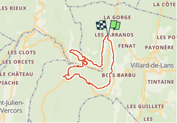
Balcons de la Bourne Valchevrieres

michelineguillot
User

Length
17.1 km

Max alt
1211 m

Uphill gradient
885 m
Km-Effort
29 km

Min alt
803 m

Downhill gradient
891 m
Boucle
Yes
Creation date :
2025-07-16 06:28:15.0
Updated on :
2025-07-16 13:45:37.203
4h53
Difficulty : Very difficult

FREE GPS app for hiking
 SityTrail
IGN / Geographical institutes
SityTrail Plus
The world is yours!
About
Trail Walking of 17.1 km to be discovered at Auvergne-Rhône-Alpes, Isère, Villard-de-Lans. This trail is proposed by michelineguillot.
Positioning
Country:
France
Region :
Auvergne-Rhône-Alpes
Department/Province :
Isère
Municipality :
Villard-de-Lans
Location:
Unknown
Start:(Dec)
Start:(UTM)
698365 ; 4995461 (31T) N.
Comments