


début Rozenn... défrichage

PatriceCocuaud
User

Length
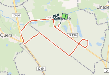
8.8 km

Max alt
345 m

Uphill gradient
110 m
Km-Effort
10.3 km

Min alt
283 m

Downhill gradient
110 m
Boucle
Yes
Creation date :
2025-07-16 13:39:47.203
Updated on :
2025-07-16 15:22:55.908
1h42
Difficulty : Very easy

FREE GPS app for hiking
 SityTrail
IGN / Geographical institutes
SityTrail Plus
The world is yours!
About
Trail Mountain bike of 8.8 km to be discovered at Bourgogne-Franche-Comté, Haute-Saône, Franchevelle. This trail is proposed by PatriceCocuaud.
Positioning
Country:
France
Region :
Bourgogne-Franche-Comté
Department/Province :
Haute-Saône
Municipality :
Franchevelle
Location:
Unknown
Start:(Dec)
Start:(UTM)
309567 ; 5290298 (32T) N.
Comments