


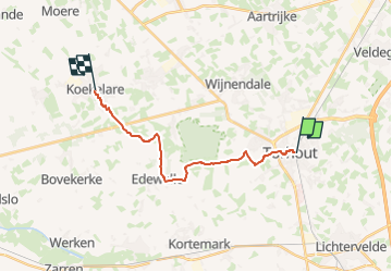
Koekelare - Torhout

FreddyTuerlinckx
User

Length
14.4 km

Max alt
44 m

Uphill gradient
77 m
Km-Effort
15.4 km

Min alt
12 m

Downhill gradient
81 m
Boucle
No
Creation date :
2025-07-16 15:33:07.792
Updated on :
2025-07-29 07:20:21.865
3h30
Difficulty : Easy

FREE GPS app for hiking
 SityTrail
IGN / Geographical institutes
SityTrail Plus
The world is yours!
About
Trail On foot of 14.4 km to be discovered at Flanders, West Flanders, Torhout. This trail is proposed by FreddyTuerlinckx.
Description
Bus 55 van Torhout station tot Koekelare Dorp
Positioning
Country:
Belgium
Region :
Flanders
Department/Province :
West Flanders
Municipality :
Torhout
Location:
Unknown
Start:(Dec)
Start:(UTM)
507386 ; 5657034 (31U) N.
Comments