


champfromier les avalanches la valserine

marcagif
User
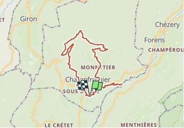

Length
17.5 km

Max alt
1209 m

Uphill gradient
779 m
Km-Effort
28 km

Min alt
536 m

Downhill gradient
778 m
Boucle
Yes
Creation date :
2025-07-17 08:12:06.039
Updated on :
2025-07-17 13:40:24.032
5h27
Difficulty : Medium

FREE GPS app for hiking
 SityTrail
IGN / Geographical institutes
SityTrail Plus
The world is yours!
About
Trail Walking of 17.5 km to be discovered at Auvergne-Rhône-Alpes, Ain, Champfromier. This trail is proposed by marcagif.
Positioning
Country:
France
Region :
Auvergne-Rhône-Alpes
Department/Province :
Ain
Municipality :
Champfromier
Location:
Unknown
Start:(Dec)
Start:(UTM)
717192 ; 5118823 (31T) N.
Comments